Water Table Depth Map for Gresham, Sandy, and Boring: How to Check Groundwater by Zip Code
If you own rental property on the rural edge of Gresham, Sandy, Boring, Damascus, or Estacada, sooner or later you will need to know how deep the groundwater sits under a specific parcel. Maybe a lender wants proof of water before approving a loan, or the county wants it before issuing a permit. Maybe a tenant just reported low pressure and you need to know whether the well itself is the problem. The good news is you can get most of the way to an answer from your desk using a water table depth map and public well records, then confirm the rest with a driller on site. This guide walks you through that process step by step, written from the ground truth of how wells actually behave east of Portland.
One thing to clear up first. You will see searches for a water table depth map in Texas, Arizona, North Carolina, or Missouri, and those states publish statewide viewers. Oregon does things differently. There is no single zip code lookup that tells you "water is at X feet under 97080." Instead, Oregon gives you something better: actual drilling records for the wells near your property. Here is how to use them.
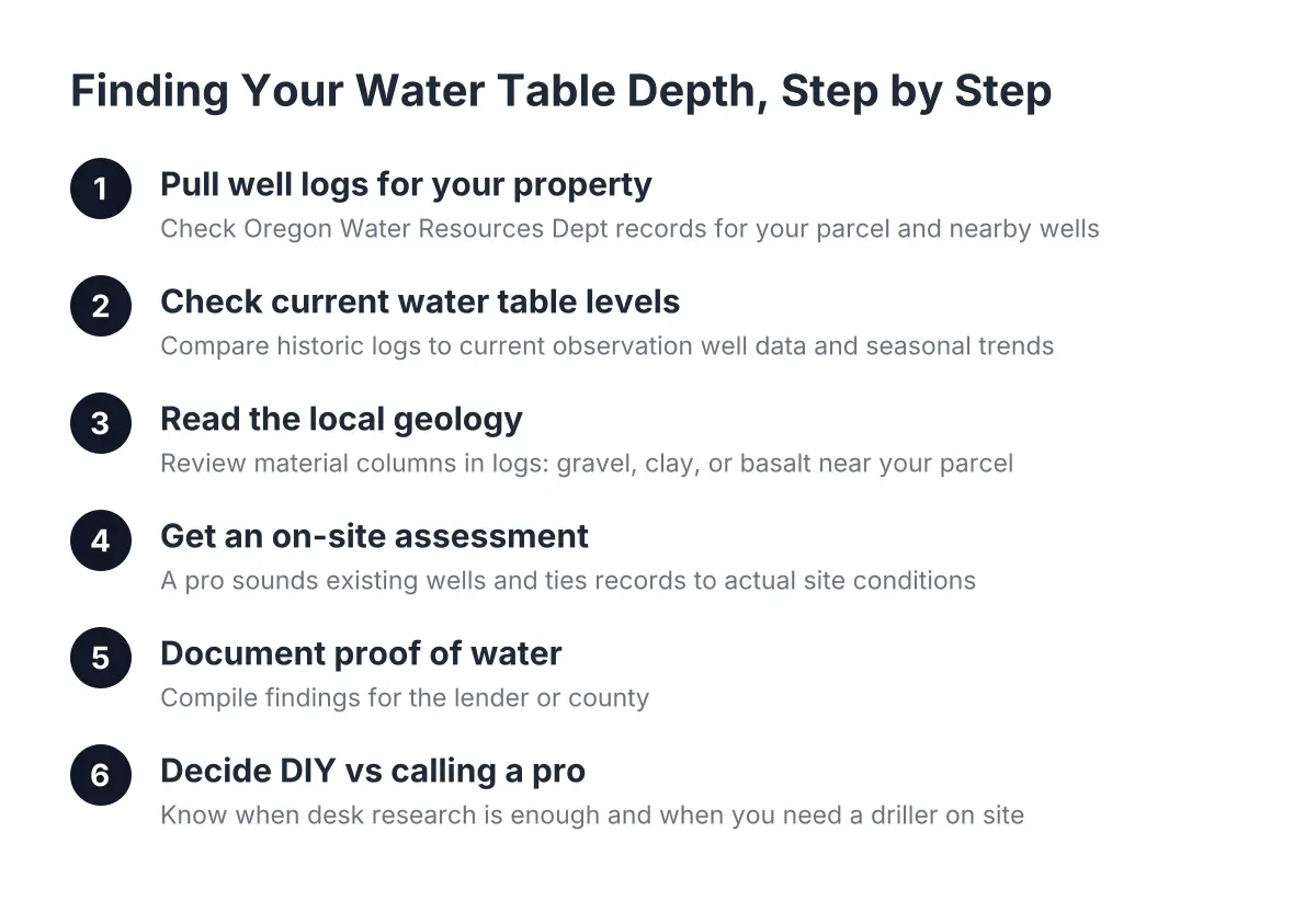
Step 1: Pull the Well Logs for Your Property and Its Neighbors
Start with the Oregon Water Resources Department well log database. Every licensed driller in Oregon files a report when a well is drilled, deepened, or abandoned. That report lists the total depth, the depth where water was first hit, the static water level, and what the drill passed through on the way down: topsoil, clay, gravel, basalt.
These well depth records by address are the closest thing you will get to a true water well depth map for the Gresham area. Search by township, range, and section, or by street address where records allow. Pull the logs for your parcel if a well already exists, then pull logs for the five or ten nearest neighboring wells.
For a landlord managing from a distance, this step matters double. You can do it from two hours away, before you authorize anyone to drive out. If three neighboring logs show water-bearing zones at similar depths, you have a realistic picture of what a new well or a deepening job will involve, and a rough sense of cost before anyone quotes you.
Step 2: Check Current Water Table Levels, Not Just Historic Ones
A well log tells you where water was on the day that well was drilled, which might have been 1987. The current water table level in your area can sit higher or lower depending on season and long-term trends. According to the Oregon Water Resources Department, the state's Groundwater Hydrology Section maintains more than 400 state observation wells and measures more than 1,200 additional observation wells across Oregon to track aquifer conditions over time.
Look up the observation wells nearest your property and note two things:
- Seasonal swing. Shallow aquifers in this area typically rise in the wet winter months and drop through late summer. A well that measures fine in March can struggle in September.
- Long-term trend. If nearby observation wells show a steady multi-year decline, a shallow well is a riskier asset for a rental you plan to hold for a decade.
This is not an abstract concern. According to the U.S. Geological Survey, about 1,220 domestic wells in Oregon went dry or fell below pumping capacity between June 2021 and December 2023, and the true number is likely higher because reporting is not mandatory. Deep wells that tap aquifers less affected by seasonal change tend to ride out dry years better than shallow ones. For a rental, that difference is the difference between a quiet summer and a no-water call from a tenant in August.
Step 3: Read the Local Geology Behind Water Table Depth Maps
The Gresham and east Multnomah County area sits where the metro's flat ground meets the Cascade foothills, and groundwater behavior changes fast across that transition. Two parcels a mile apart in Boring or Damascus can need different wells because the layers underground change: glacial gravels in one spot, dense clay or basalt in another.
This is why a national water table depth map, the kind you would use in Wisconsin or Mississippi, cannot answer the question for a specific parcel out here. The National Ground Water Association's Water Well Map holds data on more than 14 million wells nationwide, which is useful context, but siting a well on your lot comes down to local logs and local experience.
When you read your neighboring well logs, look at the materials column, not just the depths. Wells drilled through loose overburden into rock are handled differently than wells finished in gravel. As a general rule of drilling practice, when the bit reaches the top of bedrock, drillers plan to go at least about 10 feet into that rock to seal off dirty surface water and set casing in a proper socket, according to New Hampshire Department of Environmental Services guidance. Depth to water, site geology and access, drilling difficulty, and the risk of a dry hole are the four factors that drive most of what you will pay.
Step 4: Get an On-Site Water Table Depth Assessment
Desk research narrows the range. It does not replace someone standing on the property. A professional assessment ties the public records to your actual site: where the rig can set up, how close the well can legally sit to the septic system and property lines, and what the neighboring logs suggest about target depth.
If the property already has a well, the assessment usually includes sounding it with a weighted tape to measure static water level and total depth. That single measurement tells a pump tech whether the existing pump is sized and set correctly, which matters when you are deciding between well pump repair and a full well pump replacement. Residential well systems typically pair a submersible pump with a pressure tank, which may sit in the well, the house, or a crawl space, according to the Indiana Department of Health; the assessment should locate and note all of it.
As a landlord, ask the company to do three things, in writing, before you authorize work:
- Send photos and a plain-English summary of what they find, so you can evaluate it without being on site.
- Coordinate access directly with your tenant and keep you copied.
- Give you a written estimate that separates the assessment from any repair or drilling work, so you approve each step on its own.
A fair quote names the depth assumptions it is based on and explains what happens to the price if the drill has to go deeper. Anyone who quotes a flat number without having looked at nearby well logs is guessing.
Step 5: Document Proof of Water for the Lender or County
For a new well, permitting and financing both come down to paperwork. During drilling, the driller keeps a log noting the depth, water production, and clarity of water encountered on the way down. Drillers also commonly continue past the first water strike; the extra depth confirms whether the flow holds steady, leaves settling space for sediment, and preserves the option to seal off a water zone later if its quality turns out poor.
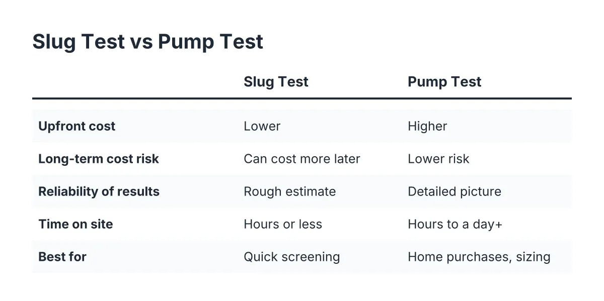
A bore can reach full depth and still produce almost nothing, sometimes a trickle, which means the hole has not reached a productive water-bearing zone. This is why lenders want a measured yield, not a driller's hunch. Well yield testing, run over hours rather than minutes, produces the gallons-per-minute figure a lender or county reviewer will accept as proof of water.
Finish with disinfection and a water test. After a new well is drilled, the driller disinfects the well and pump components with chlorine, and the well should be run heavily afterward to flush the residue, per San Diego County Department of Environmental Health guidance. It is standard practice to then pull a water sample for testing, running the well extensively first so the sample reflects normal water quality, according to the CDC. For a rental, keep that test report in the property file; you will want it at the next tenant turnover.
When to Handle It Yourself and When to Call a Pro
You can safely do Steps 1 through 3 yourself: pulling well logs, checking observation well data, and reading the geology. Sounding a well, yield testing, and anything involving the pump, wiring, or wellhead seal belongs with a licensed professional; an improperly opened wellhead can contaminate the water your tenant drinks. If a tenant reports no water, do not wait for a research project. That is a call-now situation, and a pump problem diagnosed early is usually cheaper than one that runs the pump dry.
Suppose, as an illustration, you own a rental outside Sandy and a pre-leasing well inspection flags weak pressure. Pulling the original well log remotely might show a shallow well in an area where neighboring logs and observation data point to seasonal decline. In that scenario, the honest options are a pump adjustment, deepening the well, or drilling new, and the right answer depends entirely on the depth numbers, which is why the records work in Steps 1 and 2 pays for itself.
One limitation worth naming: no map, log, or assessment can promise water at a specific depth before the drill turns. Geology east of Portland is variable enough that even careful desk work carries some dry-hole risk, and an honest well drilling company will say so in the estimate rather than after the fact.
If you own well-served rentals around Gresham, Sandy, Boring, Damascus, Estacada, or Corbett and need an assessment, a well inspection, or pump and well repair you can manage from a distance, reach out to a local well drilling and well pump repair specialist in Gresham for a written estimate. Bring the well logs you pulled in Step 1; the conversation will be shorter and the quote will be sharper.
If you need well drilling, Clackamas Well Drilling can help.
Related guide: aquifer and well depth assessment — Complete Guide
Prefer to talk it through? Call (503) 782-5215 — a quick call is usually the fastest way to get a straight answer for your situation.